


Applications & special services
Orthophoto: measurable like a drawing, photorealistic like a photograph
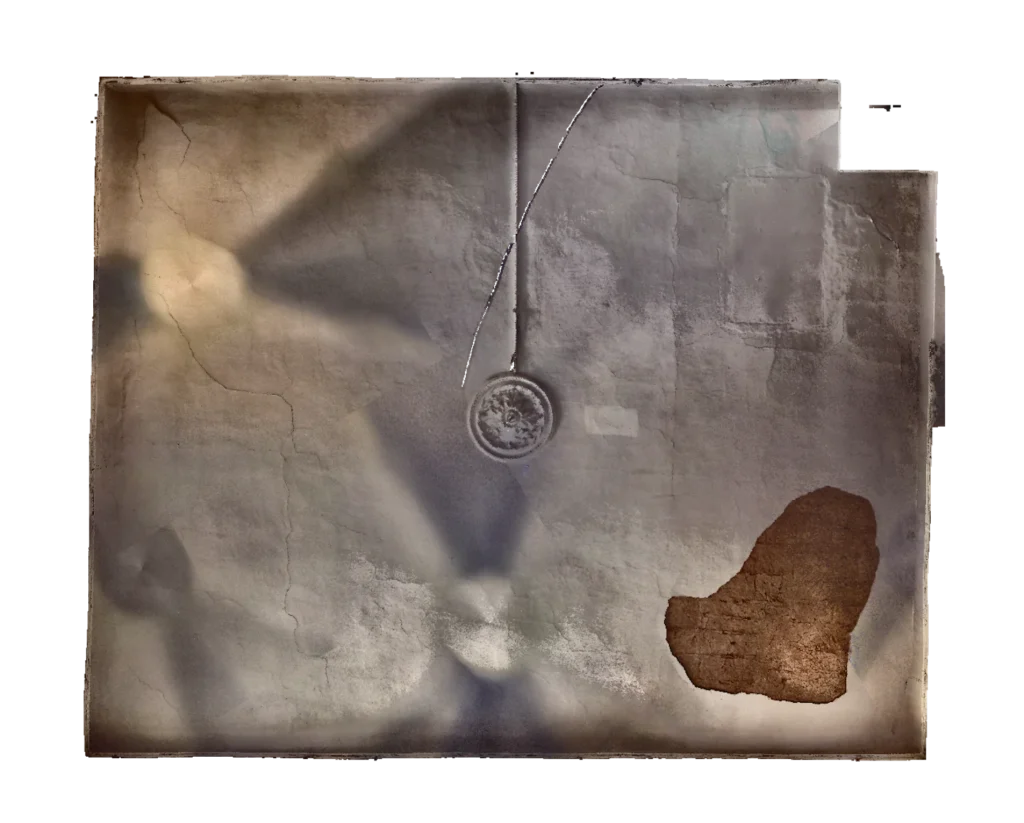
An orthophoto is a true-to-scale, distortion-free image of a surface. Unlike a photograph it has no perspective: every point is shown vertically, so you can measure in it as in a drawing. Unlike a drawing it shows the actual condition: cracks, efflorescence, discolouration, patch repairs.
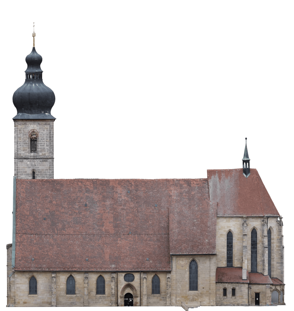
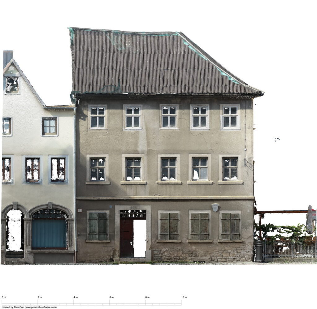
An orthophoto of a façade
Photorealistic and true to scale at the same time: in this view you can measure as you would in a drawing. For damage mapping that is the difference between a photograph and a working basis.
The four variants
- Plan view as a floor plan: the storey level from above, true to scale.
- Vertical façade elevation: the building envelope without perspective distortion, elevation by elevation.
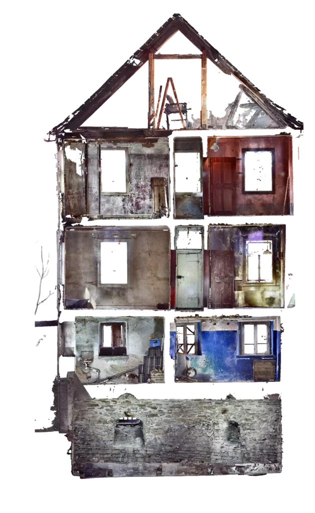
- Section: a cutting plane through the building with the real surface.
- Roof plan view from the drone: the complete roof area, including where nobody can climb.
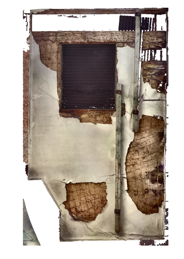
Condition documentation of roof and façade
The most common occasion is condition documentation. Maintenance is not a one-off event but a cycle: once the condition has been documented to scale, the next round compares against a dependable baseline instead of against a memory. The orthophoto is the right medium for that because it combines position and condition in a single document.
From the same capture, the documents for maintenance planning in building operation arise at no extra effort.
Further applications
- Damage and crack mapping: defects are located and recorded in their extent, not merely described.
- Heritage conservation: façade documentation without scaffolding and without touching the fabric. On a listed building the orthophoto is also the base on which conservators map their findings, congruent with the deformation-accurate survey from the same capture.
- As-built documentation before conversion: the state before intervention, recorded as evidence.
- Securing evidence: the documented initial state before works in the vicinity.
Securing evidence: the orthophoto as a dated document
Those who build often end up negotiating about states nobody can any longer prove. Was the crack in the neighbouring gable already there? What did the access road look like before the heavy transports rolled? An orthophoto answers that differently from a collection of individual photographs: it covers the whole area rather than points, is true to scale rather than perspectival, can be located in national coordinates on request, and carries an unambiguous capture date. Every spot can be located and measured afterwards, including the ones nobody thought of during the site visit.
Typical occasions: pipeline and cable routes across agricultural land, construction work next to existing buildings, the handover of leased and rented areas, evidence of land restoration. It makes sense to capture before works begin and after they are finished, because only the comparison of both states answers whether a change was caused by the works.
For a grid operator we captured the corridor of a buried cable route as a continuous orthophoto and derived from it the evidence towards the affected landowners.
Resolution, accuracy and reference to standards
What resolution an orthophoto needs depends on what has to be recognisable in it. A condition overview makes different demands from crack mapping. The rule behind it is simple: what is at least two pixels across can be reliably recognised. Anyone who knows which feature they want to find therefore knows the ground resolution required.
That is why we do not quote blanket figures but fix the resolution to the purpose before capture, write it into the quotation and demonstrate it on the delivered orthophoto. For orientation: roof and terrain captures from the drone are usually 1 to 3 centimetres per pixel, less at low flight altitude; with surveyed control points the positional accuracy reaches 2 to 5 centimetres. On a façade, terrestrial capture achieves considerably finer resolutions down into the millimetre range, depending on the capture distance and method.
For comparison: the official digital orthophoto of the German state survey (DOP20) has 20 centimetres per pixel and a multi-year update cycle. Every one of our captures is finer by a multiple and carries the date of the day it was taken.
Why a photograph cannot do this
An ordinary photograph is a central projection: everything further from the camera appears smaller, and everything off the centre of the image tips outwards. On a façade that means a window at the edge looks different from the same window in the middle, and neither of them can be measured.
The orthophoto comes about differently. It recomputes the capture into a parallel projection, as a drawing has. Every pixel then sits where it lies in reality, and the scale holds across the whole surface. It is therefore a drawing that looks like a photograph, not a photograph with a scale bar.
The basis for that is a capture with known geometry: the point cloud supplies the spatial position of every pixel. Without that basis an image can be rectified but not made measurable.
What you receive and how you work with it
Depending on your working environment, the orthophoto is delivered as a GeoTIFF with spatial reference, as a TIFF with world file, as a PDF image plan with a scale statement, or as a CAD underlay in DWG and DXF. It can then be hung into CAD and GIS as a background and dimensioned directly.
Measurability comes from the true scale and the spatial reference, not from dimension lines drawn in: you measure in the viewer or in CAD at any point you like. A fixed dimensioned output of individual areas is available as an option where a document with fixed dimensions is required.
In practice, mapping is done on the orthophoto: cracks, moisture damage, render detachment, joints. Because the image is to scale, every entry has a position and a size, and because it is an image, the next round shows whether anything has changed. Precisely that repeatability is why condition documentation is commissioned again and again.
For handover to a CAFM system the same applies as elsewhere: the mapping is only worth as much as its location reference. A damage image without a reference to the component is a photograph in a folder.
When an orthophoto is not worth it
Three cases in which something else is the better answer:
It is about geometry, not condition. Anyone needing dimensions for design is better served by as-built drawings. The orthophoto shows surface, not build-up.
The surface is obscured. What lies behind vegetation, scaffolding or neighbouring buildings is not in the orthophoto either. That is not a question of resolution but of line of sight.
It is meant to be walkable. For coordination within a team a virtual tour is more vivid. Measuring in it, however, does not carry the same authority.
Often the answer is a combination anyway: the orthophoto for the mapping, the drawing for the design, both from the same capture and therefore congruent.
Further reading
- Drone surveying – the capture for roof plan views and outdoor areas
- 3D laser scanning – terrestrial capture for façades and interiors
- Terrain model – the height model from the same flight
- 2D as-built plans – the drawn complement to the photorealistic image
- Deformation-accurate survey – when the fabric departs from regular dimensions
- CAFM data foundation – condition data in maintenance planning
Frequently asked questions about orthophotos
What is an orthophoto?
A true-to-scale, distortion-free image of a surface. Every point is shown vertically, so distances and areas can be measured directly in it, while the actual condition is shown photorealistically.
How does an orthophoto differ from a photograph?
A photograph has perspective: what is further away appears smaller, edges converge. In the orthophoto the perspective has been computed out. That makes it measurable; a photograph is not.
How does an orthophoto differ from an as-built drawing?
The as-built drawing is an interpretation: drawn lines standing for components. The orthophoto shows the real surface with everything on it. For questions of condition the orthophoto is the better basis, for questions of design the drawing.
Can cracks be measured in an orthophoto?
Yes. The position, course and extent of cracks can be recorded and mapped directly. For the question of the crack width from which detection is reliable, the two-pixel rule applies: the ground resolution must be at least half as fine as the smallest feature to be found. Whether the required crack width is achievable with the planned capture is settled before commissioning; very fine cracks we capture specifically with high-resolution close-ups of the affected areas, embedded in the same orthophoto.
What resolution do I need?
The one that shows your smallest relevant feature with at least two pixels. For a condition overview of roof and terrain, 1 to 3 centimetres per pixel from the drone is enough; for damage mapping on a façade, terrestrial capture works considerably finer. Higher resolution means denser capture and larger data volumes, so we fix it to the purpose rather than setting it to maximum across the board. What has been agreed is stated in the quotation and demonstrated on the result.
In which formats is it delivered?
As a GeoTIFF with spatial reference, a TIFF with world file, a PDF image plan, or a CAD underlay in DWG and DXF. Georeferenced, the orthophoto can be placed correctly in GIS and CAD and overlaid with drawings from the same capture.