


Applications & special services
Virtual tours: the building walkable, without travelling
A tour is not a picture gallery. It is the walkable version of the same capture that produces the floor plan and the model: you stand in the room, turn around, walk on and see the building as it was on the day of capture.
Walk through it yourself
A tour is not a picture gallery. It is the walkable version of the same capture that produces the floor plan and the model: you stand in the room, turn around, walk on and see the building as it was on the day of capture.
In a project it replaces appointments. Anyone looking for a service run, checking a ceiling height or showing a spot to a specialist designer does not have to travel there.
The tour below comes from one of our own captures.
The tour is only loaded once you start it. Until then no request goes to the provider.
What a tour stands for in a project
In a project the tour replaces appointments. Anyone looking for a service run, checking a ceiling height or showing a spot to a specialist designer does not have to travel there. Building managers save the drives for “just quickly checking something”, site meetings take place at the current construction state, and a design project at the other end of the country becomes tangible without anyone getting into a car.
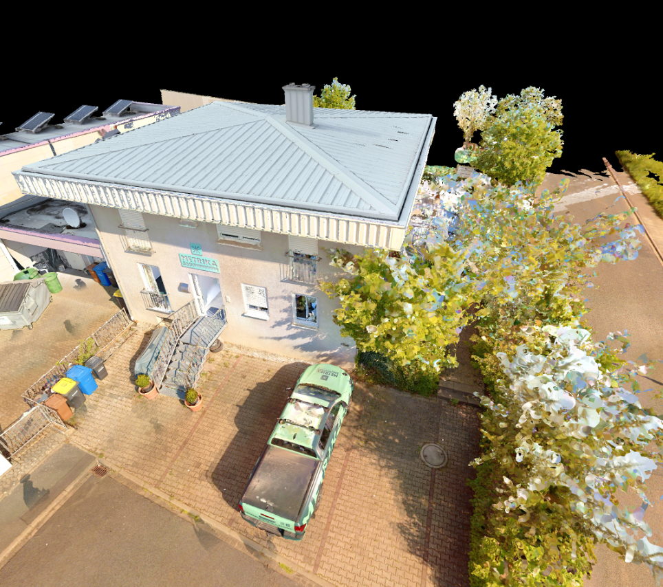
With us the tour arises as a by-product of 3D laser scanning: the same walk-through that produces the floor plan and the room book also produces the tour. One visit, three results.
Why laser scan data makes the difference
There are plenty of virtual tours made from photographic data. Ours come from laser scan data, and that changes three things:
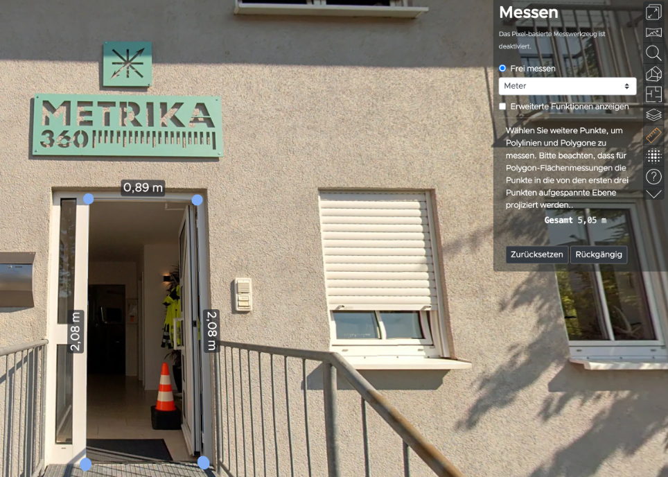
You can measure inside the tour. Because every panorama is linked to the point cloud, length and area measurements are possible directly in the tour, accurate to the centimetre. A door width, an axis dimension, a footprint: measured on screen instead of estimated from a photograph.
The tour sits in the right place. Every panorama position is located. The tour is congruent with the floor plan and the model instead of being a loose collection of photographs.
The tour stays current without us coming back. If an area changes, you take a few new panorama photographs there yourself and upload them. The algorithm recognises the features and puts the images in the right place in the building. As long as it is not a complete rebuild, we come exactly once. That is the point at which the economics are decided.
What you can do with it
Measure instead of estimate. Lengths and areas directly in the tour, for relocation planning, furnishing, site checks.
Mark places and find them again. Annotations anywhere in the building: the distribution board, the water damage, the inspection sticker. Searchable across tours, including through the text recognised on signs and labels in the panoramas.
Data protection built in. People and number plates are made unrecognisable in the panoramas in line with the GDPR. Captures taken while the building is in use therefore remain publishable.
Show what is meant to be shown. Panorama positions can be switched on and off, for tenants, buyers or external service providers. Guided tours lead visitors through the building on a fixed path.
Compare construction states. With repeat capture the tour becomes a journey through time: the same position in several states, switchable with a slider. That is the walkable version of construction progress documentation.
Portfolio at a glance. Several properties on one map, every tour reachable from its location. For estates rather than single buildings.
The tour as an interface to your CAFM
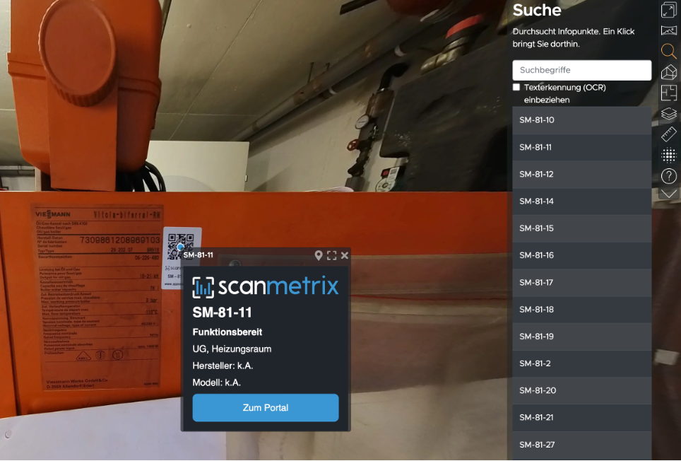
The markers in the tour can be linked bidirectionally with selected CAFM or asset management systems: open a room in the system and you jump into the tour; click a piece of plant in the tour and you see its data sheet. That lowers the barrier to entry considerably, because a tour in the browser needs no training.
The commercial effect behind it: tour packages are billed, not users. The colleague who only wants to check whether there is a radiator in the room needs no CAFM licence of their own. Any system with a web interface can be connected, including live data from production on request.
Hosting and security
The tours run in the browser, with no installation on the user’s side. Hosted to your requirements, on request as an offline or on-premise solution behind your own firewall, with redundant servers for uninterrupted operation. For the roll-out we train the group of staff responsible.
Where tours are in use today
- Concept design, feasibility studies and design in existing buildings
- Site documentation, site meetings and site inspections
- Checking settlement documents against the documented state
- Digital twins of production facilities, with live data on request
- Training in occupational safety and work processes on the real building
- Facility management and space management
“Working with Metrika360 was straightforward; genuinely everything was handled efficiently. The advice throughout the project was of the highest calibre. The site has been enjoying the added value created by the Metrika360 team ever since.”
Atilla Arslantepe
Aenova Group
Automation & Digitalization Engineer
Pricing
What virtual tours cost
Further reading
- 3D laser scanning – the capture the tour arises from along the way
- Room book – the attributes for the walkable building
- CAFM data foundation – where the markers run to
- Construction progress documentation – the tour as a journey through time
Frequently asked questions about virtual tours
What distinguishes tours from laser scan data from ordinary 360-degree tours?
Three things: you can measure to the centimetre inside the tour, because every panorama is linked to the point cloud. The positions are located and congruent with the plan and the model. And the tour can be updated with panoramas you take yourself, without a new survey run being necessary.
Does it need a capture of its own?
No, and that is the point: the tour arises as a by-product of the same walk-through that also produces as-built drawings, the room book or the model. Anyone having a survey done anyway gets the tour from the same visit.
How does the tour stay current when work is carried out?
For isolated changes you take new panorama photographs yourself and upload them; the software puts them in the right place automatically. For larger alterations a repeat capture is worthwhile, which at the same time documents the construction state and allows the time comparison inside the tour.
Who can see the tour?
You control that: public, by link, or restricted to defined user groups. Individual areas and panorama positions can be hidden. People and number plates are made unrecognisable before release.
What does a virtual tour cost?
Production depends on area and capture situation, hosting on the number of tours and the features required. Tour packages are billed, not users, so the cost does not scale with the size of your team. Tell us the property and the purpose and you will get a dependable order of magnitude.
Can the tour be connected to our CAFM system?
Yes, bidirectionally through web interfaces: markers in the tour link to the records in the system and vice versa. Which systems can be connected in a given case we settle at the start; most systems with an API can be integrated.