


The basis for every good design
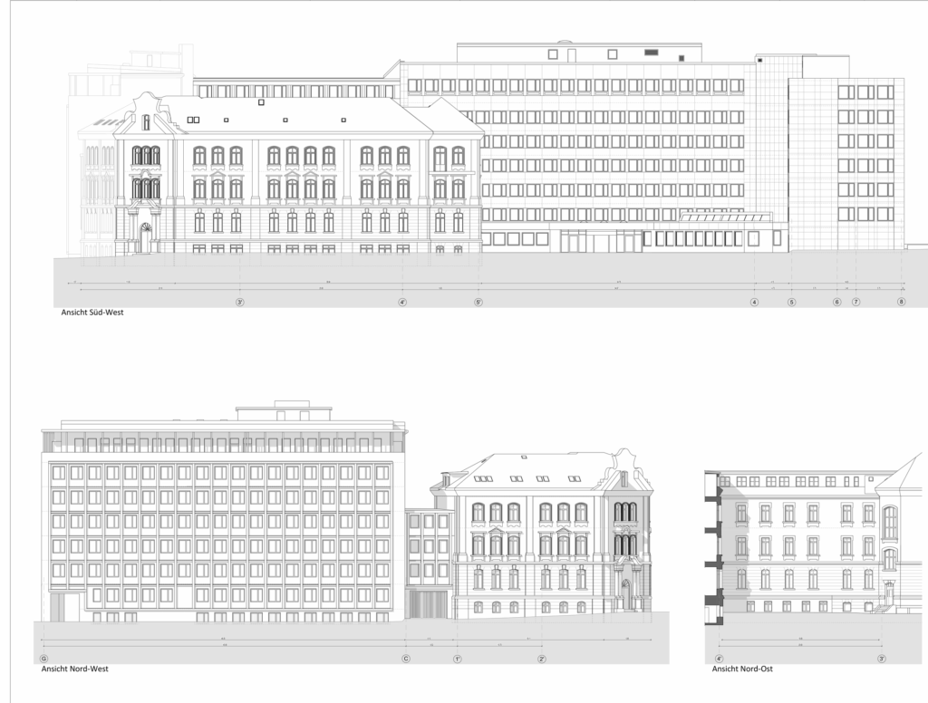
2D as-built plans: floor plans, sections and elevations from the laser scan
Drawn from a current 3D capture instead of traced from documents whose age nobody knows.
What an as-built plan from us is
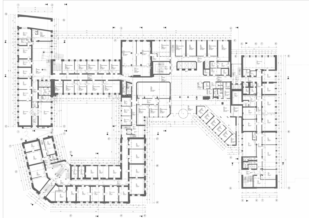
A 2D as-built plan shows a building as it is today. Metrika360 captures the existing building by 3D laser scanning and draws floor plans, sections and elevations from it, with room stamps, dimensions, window and door stamps and areas to DIN 277, on request to the German Living Space Ordinance or MF-GIF. Handover is in DWG, DXF and PDF, the room book as Excel, set up to your CAD guideline with the agreed layer structure and title block.
How the point cloud underlying every drawing comes about is set out under 3D laser scanning: terrestrial, on the move or by drone, including while the building stays in use.
Scan-to-CAD: from point cloud to drawing in five steps
Kick-off
Objective, level of detail, deliverables and accessibility. What you can prepare is set out in the checklist "preparing a building for 3D capture".
Capture on site
Terrestrial, mobile or by drone, depending on the building, without interrupting operations.
Processing and registration
The individual scans are computed into one georeferenced overall point cloud, cleaned and checked.
Drawing
The point cloud serves as a template. Drawing follows your CAD guideline, at the agreed level of detail.
Quality assurance and handover
Every drawing is checked against the point cloud and handed over in the agreed formats.
The four states of the data
Between capture and finished plan set there are intermediate states, and each is a deliverable in its own right.
- Point cloud. The measurement result: millions of points with position and colour, as yet without interpretation.
- Section. The first step of interpretation: a plane through the building.
- Floor plan. Drawn from the capture, not traced from an old drawing.
- Model. Components instead of lines, when more is needed than the drawing: BIM as-built models.
A section shows what a floor plan cannot: clear heights, floor build-ups, roof pitch. Precisely the information that is rarely right in drawings from the time of construction, because it was decided while building and not while designing.
What the drawing contains
An as-built plan is more than an outline. What we hand over is designed for further processing:
- Floor plans per storey at 1:100, to your CAD guideline with the agreed layer structure and title block
- Room polygons as closed areas and a room stamp per room
- Areas to DIN 277: gross floor area, construction area and net room area, divided into usable, services and circulation area. For residential space additionally to the Living Space Ordinance, for commercial letting to MF-GIF
- Window and door stamps with clear dimensions and sill heights, level marks to finished floor level, and in the attic the one- and two-metre lines
- Sections and elevations from the same capture
The full scope per level of detail is defined by our drawing and modelling standard. Request it and attach it to your tender, and you will be comparing quotations on the same basis.
Who for and what for
Property management and operation. Drawings and a room book that can be imported directly into your CAFM system, with a test import before handover.
Designers and building in existing fabric. The basis for refurbishment and conversion: what deviates from the assumption by three centimetres in the existing building costs a multiple of the survey during construction. On request we carry on designing on this basis, up to the building application.
Developers and marketing. Dependable floor plans and living areas to the Living Space Ordinance for sale and letting, from the same capture as the design basis.
Listed buildings. Deformation-accurate as-built plans that show deformations instead of straightening them out. Often a precondition for heritage funding.
Why it pays off
Using old drawings is more expensive than it looks: the designer checks dimensions individually, orders on suspicion, and the first undetected error costs more than the whole new survey. A current as-built plan saves site visits and check measurements, design errors from false assumptions, wrong order quantities and wrong settlements.
That becomes particularly clear in serial refurbishment: for refurbishment with prefabricated elements funded under the German BEG and KfW schemes, the parts have to be made to measure. An element produced in the factory has to fit at the scaffold on the first attempt, and it only does so against the measured existing building.
When a drawing is not enough: the BIM as-built model
The 2D plan set answers the area and the geometry. A BIM as-built model can do more: components with attributes instead of lines, automatic quantity and volume take-off, clash detection with the services design, and the 2D drawings are already contained in it as a derivation. Anyone who can foresee designing or refurbishing is better off with the model, because the capture is the same.
The switch is possible later too: the point cloud remains, and the model can be ordered afterwards without a new site visit.
You already have a point cloud?
Then the capture can be omitted. You send us the point cloud in E57, LAS/LAZ or RCP/RCS, we check registration, completeness, point density and coordinate reference, and tell you what can be drawn from it and at what quality. Only then do you get a quotation.
We name one limit openly: we draw from your point cloud. For its accuracy and its agreement with the building we accept no warranty, because the capture was not ours. Recognisable gaps we mark as an assumption. If the data quality is not sufficient we say so before commissioning and state the effort for a re-capture.
Further reading
- 3D laser scanning – the capture every drawing grows out of
- BIM as-built models – components instead of lines, when more is needed
- Room book – the alphanumeric half of your as-built data
- Deformation-accurate survey – for listed and distorted buildings
FAQ on 2D as-built plans
What is in an as-built plan from Metrika360?
Floor plans per storey at 1:100, room stamps with number, name and area, room run dimensions, one level mark to finished floor level per room, window and door stamps with clear dimensions and sill heights, and in the attic the one- and two-metre lines. Sections and elevations from the same capture.
To which standard are the areas calculated?
To DIN 277 for operation, funding and administration. For residential letting to the Living Space Ordinance, for commercial letting to MF-GIF. Which standard applies is decided by the intended use, and we settle that before the project starts.
How current are the plans?
As current as the day of capture, and that date is in the title block. That distinguishes the plan from any archive holding: you know what it shows and from when.
Is the plan enough for a building application?
As a basis for approval documents yes, georeferenced and ready to connect. Whether your project additionally needs an official site plan depends on the German state and the measure; we settle that in advance.
Can you draw to our CAD guideline?
Yes, that is the normal case: layer structure, title block and stamp conventions to your specification, and with a CAFM connection a test import into your system before handover. Without an agreement our Metrika360 drawing and modelling standard applies.
We already have a point cloud. Will you draw from it?
Yes, after checking registration, completeness and point density. The warranty then relates to the drawing made from your point cloud, not to its accuracy or its agreement with the building.
Do I need drawings or a model?
Rule of thumb: if the purpose is only to document, administer or let, the plan set is enough. If design or refurbishment is coming, the model pays off.