


Point cloud: the raw result of every laser scan survey
A point cloud is the set of all measured points of a survey, each with coordinates and usually a colour value. It is the raw result: not a drawing and not a model, but the measurement itself.
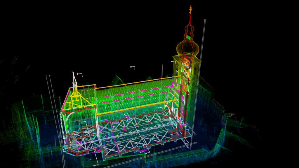
A point cloud with the model on top
Millions of individual points, computed together from several scanner positions, with the drawing derived from them on top. The point cloud is kept as evidence, even when the model has long since been passed on.
From individual scans to a complete dataset
Each scan only sees what is visible from its position. Registration brings the individual scans together into a common coordinate system. Only then does the building exist as one dataset. The quality of this step determines everything that follows – an error in registration carries over into every derived drawing.
After registration comes cleaning: people, vehicles and measurement artefacts are removed. We check the result under the four-eyes principle before anything is drawn from it.
Why the format matters
Point clouds are often delivered in proprietary formats. That ties the client to one software package. E57 is the vendor-neutral exchange format – if you want to reuse the point cloud later, you should agree on E57.
The point cloud is also the only result that records the condition completely. A drawing shows what was drawn; the point cloud shows what was there. For later queries, that is the difference between measuring again in the data and driving out to site again.
What a point contains
Each point carries at least its position in space: three coordinates. Added to this is the intensity value – how strongly the emitted light came back. It depends on material, surface and angle of incidence, and it makes changes of material visible, even where nothing happens geometrically. If photographs are also taken, each point receives a colour value.
These three layers explain why a point cloud is more than a survey: you see the geometry, you see material boundaries, and you see the building as it looked.
How registration works
There are two ways of combining the individual scans, and they are not mutually exclusive.
- Using targets. Before the survey, they are distributed around the building so that they are visible in several scans. This takes more preparation and provides the more reliable link.
- Using the point cloud itself. The software searches overlapping areas for shared geometry. This saves the targets but needs sufficient overlap and structure – in a long, empty corridor the method finds little to hold on to.
In both cases a residual deviation remains, and it belongs in the report. A point cloud without a statement of registration accuracy is an assertion.
Density is not an end in itself
Point density indicates how closely the measured points lie on a surface. It is not a value to maximise but one to choose for the task: documenting crack patterns on a facade requires a different density from finding room edges for a floor plan.
Higher density costs survey time on site and processing time afterwards, and it produces files that can no longer be passed on easily. That is why the question of purpose comes before the question of resolution.
What it can and cannot do
A point cloud measures what light has reached. What was hidden is missing – behind furniture, above suspended ceilings, in closed shafts. It also does not recognise components: a wall in it is not an object but a collection of points on a plane. Turning the cloud into components is the step that Scan-to-BIM describes.
What it can do instead: it allows any measurement after the fact. A question that comes up during design and that nobody asked during the survey can be answered from the dataset, as long as it concerns visible geometry.
Why it is kept
Models and drawings are interpretations. They contain decisions about what is shown and what is not. The point cloud does not contain these decisions – it is the evidence against which every later drawing can be checked.
That is why it belongs in the handover, even if day-to-day work is done with the drawings. Without it, you will not be able to prove in two years what the building looked like at the time of the survey – provided it is georeferenced.
Frequently asked questions
What is a point cloud?
The set of all measured points of a laser scan survey, each with coordinates and usually a colour value. It is the measurement itself, not its interpretation.
In which format should a point cloud be delivered?
In E57. That is the vendor-neutral exchange format. Proprietary formats tie later use to a specific software package.
Why do you need the point cloud if there are drawings?
The drawing shows what was drawn; the point cloud shows the actual condition. For later queries, measurements can be taken in it without travelling to site again.
What does registration mean?
Combining the individual scans into a common coordinate system. This is done using targets in the building or using shared geometry in overlapping areas. The remaining deviation belongs in the report.
What point density do I need?
That depends on the task. Room edges and floor plans need less than documenting crack patterns on a facade. Higher density costs survey time, processing time and file size without being useful for every question.
Does a point cloud also see what is behind furniture?
No. What light reaches is measured. Hidden areas are missing – behind built-in fittings, above suspended ceilings, in closed shafts. Whatever is needed there has to be opened up or captured separately.
Does a point cloud recognise components?
No. A wall in it is a collection of points on a plane, not an object with properties. Turning it into a component is the step that Scan-to-BIM describes.